


Notice of Committee Hearing
The Public is invited to participate in a Committee of Adjustment hearing on Thursday, June 26, 2025 at 2:00 p.m.
How to Participate
Submit written comments, by emailing Arden.Irish@thunderbay.ca no later than Wednesday, June 18, 2025. Please quote the file number in your submission.
Participate online using Microsoft Teams. Online participants must register by the end of the day on Wednesday, June 18, 2025. Please email Arden.Irish@thunderbay.ca to register.
Attend in person, by visiting Council Chambers on the 3rd Floor of City Hall (500 Donald Street East)
Watch live from home by visiting www.thunderbay.ca/watchcouncil
Additional Information
If you wish to be notified of the decision of the Committee of Adjustment in respect of the proposed consent, you must submit a written request to Arden.Irish@thunderbay.ca.
Copies of all comments will be forwarded to the Committee and to the Applicant. The collection of personal information including names and contact information provided in written submissions is made under the authority of the Planning Act for the purpose of creating a Public Record. Personal information is collected in compliance with the Municipal Freedom of Information and Protection of Privacy Act.
Right to Appeal
Only the applicant, the Minister or a specified person or public body that has an interest in the matter may, within 20 days of the making of the decision, appeal to the Ontario Land Tribunal against the decision of the Committee of Adjustment.
Questions?
If you have any questions about this notice or you require accessible accommodations or materials, please contact:
Arden Irish
Acting Committee of Adjustment Secretary Treasurer
(807) 625-2704
Consent to Sever Applications
B-34-2025: 5200 Loch Lomond Road
The purpose of this application is to create one new parcel of land.
The Severed Lot will have a Lot Frontage of 247 m, an irregular Lot Depth of 116 m, and a Lot Area of 21,064 m2. The Retained Lot will have a Lot Frontage of 233 m, a Lot Depth of 400 m and a Lot Area of 167,333 m2.
If approved, the effect of this application would be the severance and conveyance of one new parcel and to establish any easements as may be required for servicing, as set forth in the application.
The lands are zoned “RU” – Rural Zone, “RUH15” – Rural Zone with Development Holding Provision H15, and “EP” – Environmental Protection Zone. The lands are designated as “Rural 1”, “Evaluated Wetland” and “Natural Corridor” in the Official Plan. The applicant’s site sketch and a key map of the subject lands are shown below.
The subject lands are not subject to any other application under the Planning Act at this time.
Key Map of Subject Lands

Applicant's Site Sketch

Minor Variance Applications
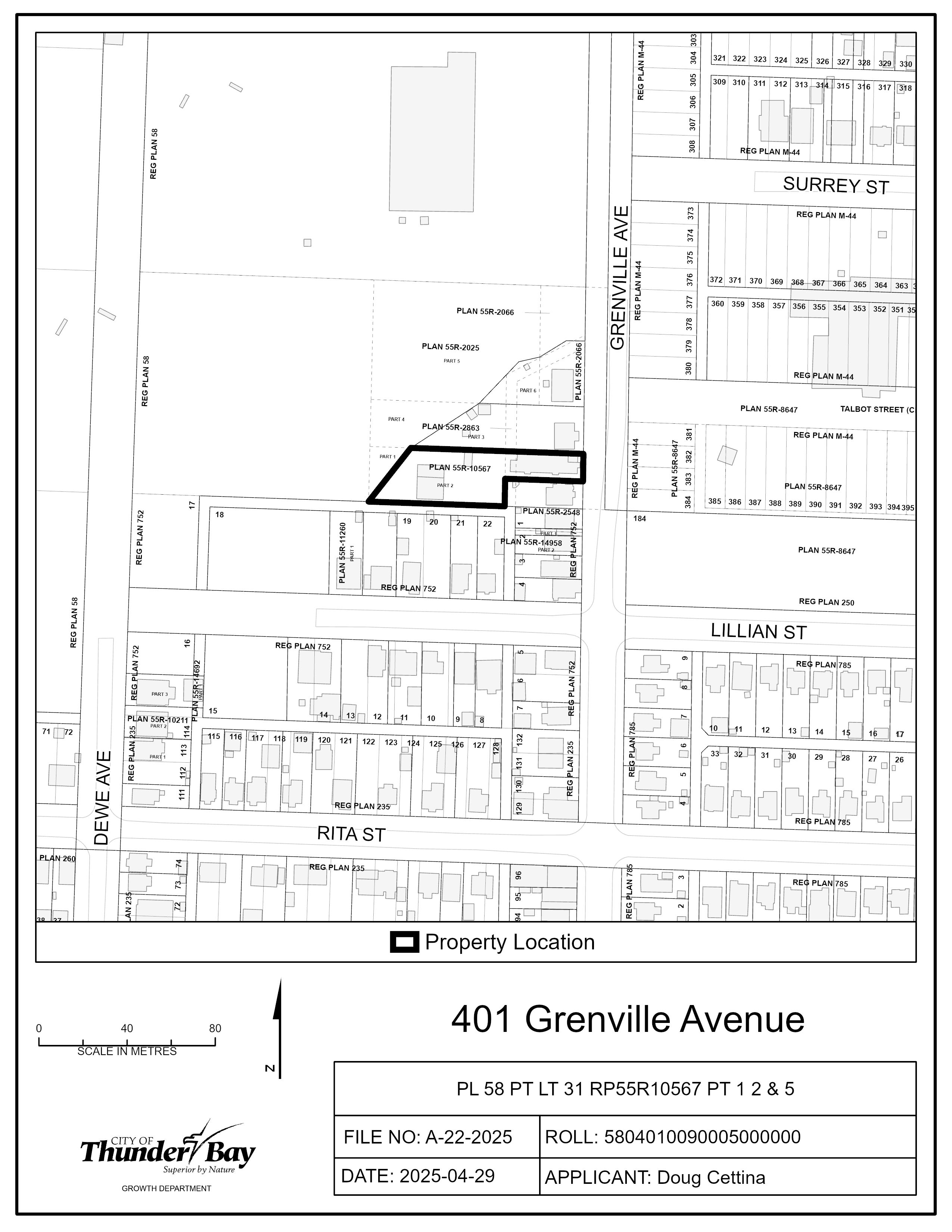
A-22-2025: 401 Grenville Avenue
The purpose of the application is to gain relief from Zoning By-law 1-2022, as set forth in the application and described below:
- Table 3.2.1a, Reduce the minimum Front Setback from 4.5 m to 2.8 m
- Table 3.2.1a, Reduce the minimum Interior Side Setback from 1.5 m to 1 m
- Table 3.2.2, Increase the maximum GFA of all Accessory Buildings from 100 m2 to 217 m2
- Table 3.2.2, Increase the maximum GFA of a Backyard Home from 40% of the Main Building’s GFA to 42%
- Table 3.2.2, Increase the maximum Height from 4.6 m to 7 m
- Table 3.2.2, Increase the maximum Wall Height from 3.2 m to 5.4 m
- Table 3.3a, Reduce the minimum Landscaped Area from 50% of the minimum Front Setback to 23% of the minimum Front Setback
- Table 11.7.2a, Reduce the minimum Driveway width from 4.5 m for two-way traffic to 3.3 m
- Section 14, Change the definition of a Detached house from a residential Building containing up to 2 Homes to a residential Building containing up to 3 Homes
If approved, the effect of this application would recognize the existing conditions on the property to allow the construction of a Backyard Home on the Subject Lands.
The subject lands are zoned “UL” – Urban Low-rise Zone and designated as “Residential” in the Official Plan. The applicant’s site sketch and a key map of the subject lands are shown below.
The subject lands are not subject to any other application under the Planning Act at this time.
Key Map of Subject Lands
Applicant's Site Sketch

A-29-2025: 369 301 Harold Street North
To gain relief from Zoning By-law 1-2022, as set forth in the application and described below:
- Table 3.1.1a, Reduce the Minimum Lot Frontage for three homes from 13.2 m to 10.6 m
- Table 3.3a, Increase the Maximum Driveway Width from 6.0 m to 8.0 m
- Section 11.6.2, Allow three adjacent Parking Spaces in a Driveway
If approved, the effect of this application would be the construction of a third unit in an existing two-unit dwelling on the subject lands.
The subject lands are zoned “UL” – Urban Low-rise Zone and designated as “Residential” in the Official Plan. A key map of the subject lands and the applicant’s site-sketch are shown below.
The subject lands are not subject to any other application under the Planning Act at this time.
Key Map of Subject Lands

Applicant's Site Sketch

A-30-2025: 740 Grey Crescent
To gain relief from Zoning By-law 1-2022, as set forth in the application and described below:
- Table 3.3b, Permit three driveways on the property
- Section 11.1.2a, Reduce the minimum separation between a Driveway and an Intersection of two Street Allowances from 9.0 m to 7.4 m
- Table 11.6.2, Reduce the minimum length of a Parking Space abutting a wall from 6.0 m to 5.69 m
If approved, the effect of this application would be the construction of a four-unit apartment building on the subject lands.
The subject lands are zoned “UL” – Urban Low-rise Zone and designated as “Residential” in the Official Plan. A key map of the subject lands and the applicant’s site-sketch are shown below.
The subject lands are not subject to any other application under the Planning Act at this time.
Key Map of Subject Lands

Applicant's Site Sketch

A-31-2025: 354 Riverside Drive
To gain relief from Zoning By-law 1-2022, as set forth in the application and described below:
- Table 10.2.2, Reduce the minimum Interior Side Setback from 10.0 m to 3.0 m
If approved, the effect of this application would be the construction of a garage on the subject lands.
The subject lands are zoned “FD” – Future Development Zone and designated as “Residential” in the Official Plan. A key map of the subject lands and the applicant’s site-sketch are shown below.
The subject lands are not subject to any other application under the Planning Act at this time.
Key Map of Subject Lands

Applicant's Site Sketch

A-33-2025: 447 Oliver Road
To gain relief from Zoning By-law 1-2022, as set forth in the application and described below:
- Table 3.1.1a, Reduce the minimum Lot Area for 6 homes from 660 m2 to 613.5 m2.
- Table 3.1.1a, Reduce the minimum Lot Frontage for 6 homes from 22 m to 15.7 m.
- Table 3.3b, Reduce the minimum Landscaped Area from 20% of the Lot Area (122.7 m2) to 19% (118.7 m2).
If approved, the effect of this application would be the conversion of the existing building into a six-unit Apartment on the subject lands.
The subject lands are zoned “UL” – Urban Low-rise Zone and designated as “Residential” in the Official Plan. A key map of the subject lands and the applicant’s site-sketch are shown below
The subject lands are not subject to any other application under the Planning Act at this time.
Key Map of Subject Lands

Applicant's Site Sketch

A-35-2025: 92 Machar Avenue
To gain relief from Zoning By-law 1-2022, as set forth in the application and described below:
- Table 3.1.1a, Reduce the minimum Lot Frontage for 15 homes from 40 m to 32.9 m
- Table 3.1.1a, Increase the maximum Height from 10.0 m to 15.0 m
- Table 3.1.1a, Increase the maximum number of Homes from 6 per Lot to 15
- Table 3.1.1a, Increase the maximum Lot Coverage from 40% to 42%
- Table 3.2.1d, Reduce the minimum Rear Setback from 6.0 m to 2.8 m
- Table 3.2.1d, Reduce the minimum Interior Side Setback from 3.0 m to 2.0 m
- Table 3.2.1d, Reduce the minimum Front Setback from 6.0 m to 3.0 m
- Table 3.3b, Reduce the minimum number of Parking Spaces from 1.25 per home to 1.0 per home
- Table 3.3b, Reduce the minimum number of Loading Spaces from 1 to 0
- Table 3.3b, Reduce the minimum Landscaped Area from 20% to 16%
- Table 13.1.1, Increase the maximum Height in Area 3 from 10.0 m to 15.0 m
- Section 11.4.1, Permit a Patio to cross over the required Landscaped Area
If approved, the effect of this application would be the construction of a fifteen-unit Apartment on the subject lands.
The subject lands are zoned “UL” – Urban Low-rise Zone and designated as “Residential” in the Official Plan. A key map of the subject lands and the applicant’s site-sketch are shown below.
The subject lands are not subject to any other application under the Planning Act at this time.
Key Map of Subject Lands

Applicant's Site Sketch

A-36-2025:
To gain relief from Zoning By-law 1-2022, as set forth in the application and described below:
- Table 3.1.2a, Reduce the maximum Lot Area for 12 homes from 1020 m2 to 1009 m2.
- Table 3.2.1a, Increase the maximum Lot Coverage from 40% of the Lot Area to 41%.
- Table 3.2.1d, Reduce the minimum Front Set-back from 6.0 m to 5.3 m
- Table 3.2.1d, Reduce the minimum Exterior Side Set-back from 3.0 m to 1.5 m
- Table 3.2.1d, Reduce the minimum Rear Set-back from 6.0 m to 1.5 m
- Table 3.2.2, Reduce the minimum Separation Distance between an Accessory Building and a Main Building on the same Lot from 2 m to 0 m
- Table 3.3b, Reduce the 3 m Landscaped Strip to 1.6 m in the Exterior Side-yard on portions not occupied by barrier free parking space and its associated aisle, and walkway from western end of building to the building entrance along Nugent Street
- Table 3.3b, Reduce the minimum number of Parking Spaces from 1.25 per Home to 1.0
- Table 3.3b, Reduce the minimum number of Loading Spaces from 1 to 0 on-site with 1 road-side Loading Space
- Table 13.1.1, Increase the maximum Height from 10 m to 12.8 m
- Section 11.1.2d, Permit primary vehicle access to a Lot from a Lane
If approved, the effect of this application would be the construction of a twelve-unit Apartment on the subject lands.
The subject lands are zoned “UM” – Urban Mid-rise Zone and designated as “Residential” in the Official Plan. A key map of the subject lands and the applicant’s site-sketch are shown below.
The subject lands are not subject to any other application under the Planning Act at this time.
Key Map of Subject Lands

Applicant's Site Sketch

A-37-2025: 1171 - 1191 Oliver Road
To gain relief from Zoning By-law 1-2022, as set forth in the application and described below:
- Table 6.3, reduce the minimum Landscape Strip in the Front Setback from 6.0 m to 1.6 m to accommodate an on-site sidewalk.
- Table 6.3, Reduce the minimum number of Parking Spaces from 176 to 151.
If approved, the effect of this application would be the construction of a Hotel and Restaurant on the subject lands.
The subject lands are zoned “BUSP10 H18” – Business Zone with Site-specific Provision 10 and Development Holding Provision 18. The subject lands are designated as “Business Area” in the Official Plan. A key map of the subject lands and the applicant’s site-sketch are shown below.
The subject lands are not subject to any other application under the Planning Act at this time.
Key Map of Subject Lands

Applicant's Site Sketch

Contact Us