


Notice of Committee Hearing
The Public is invited to participate in a Committee of Adjustment hearing on Thursday, May 29, 2025 at 2:00 p.m.
How to Participate
Submit written comments, by emailing Arden.Irish@thunderbay.ca no later than Wednesday, May 21, 2025. Please quote the file number in your submission.
Participate online using Microsoft Teams. Online participants must register by the end of the day on Wednesday, May 21, 2025. Please email Arden.Irish@thunderbay.ca to register.
Attend in person, by visiting Council Chambers on the 3rd Floor of City Hall (500 Donald Street East)
Watch live from home by visiting www.thunderbay.ca/watchcouncil
Additional Information
If you wish to be notified of the decision of the Committee of Adjustment in respect of the proposed consent, you must submit a written request to Arden.Irish@thunderbay.ca.
Copies of all comments will be forwarded to the Committee and to the Applicant. The collection of personal information including names and contact information provided in written submissions is made under the authority of the Planning Act for the purpose of creating a Public Record. Personal information is collected in compliance with the Municipal Freedom of Information and Protection of Privacy Act.
Right to Appeal
Only the applicant, the Minister or a specified person or public body that has an interest in the matter may, within 20 days of the making of the decision, appeal to the Ontario Land Tribunal against the decision of the Committee of Adjustment.
Questions?
If you have any questions about this notice or you require accessible accommodations or materials, please contact:
Arden Irish
Acting Committee of Adjustment Secretary Treasurer
(807) 625-2704
Consent to Sever Applications
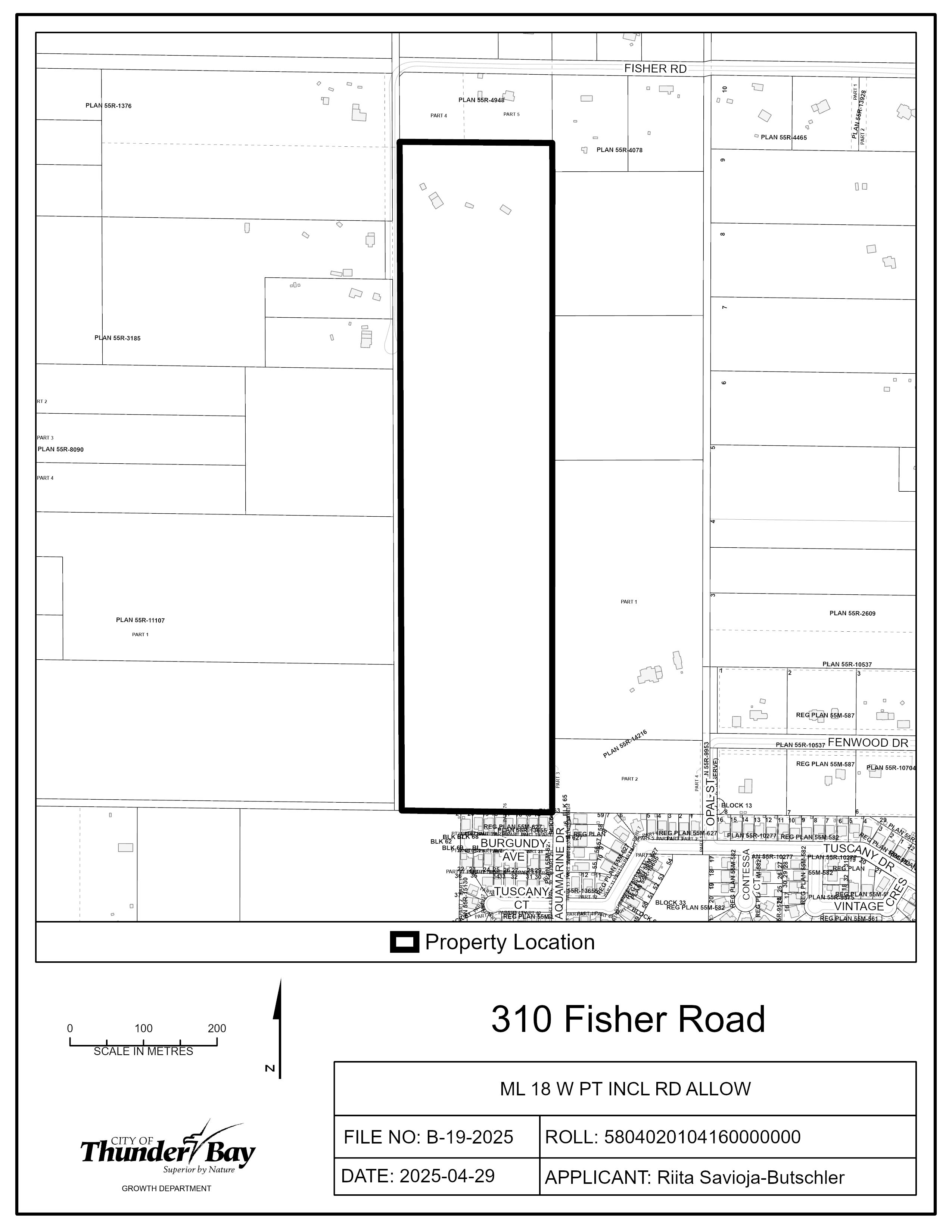
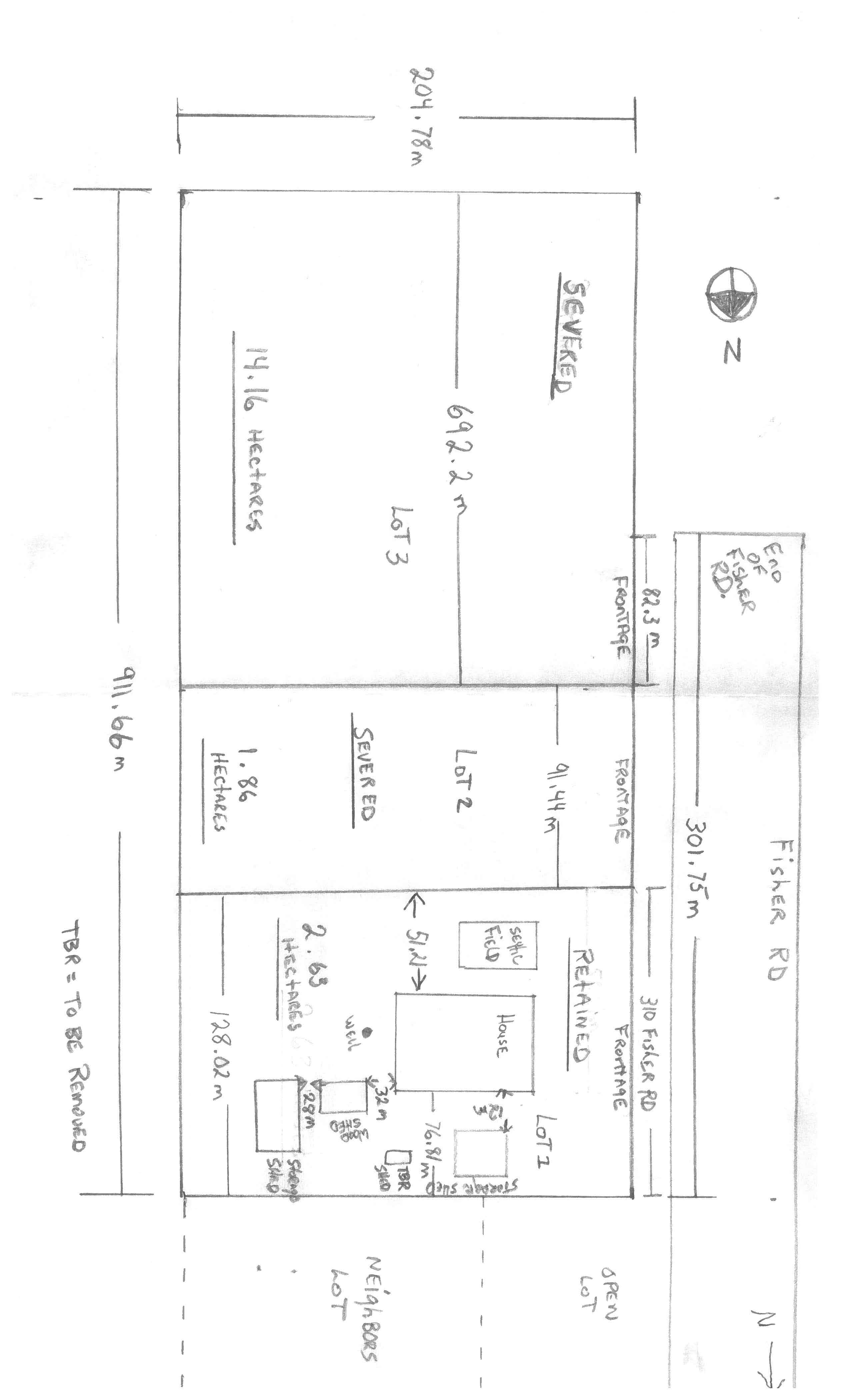
B-19-2025: 310 Fisher Road
The purpose of this application is to create two new parcels of land.
Severed Lot 1 will have a Lot Frontage of 91.44 m, Lot Depth of 204.78 m and Lot Area of 18 725.08 m2. Severed Lot 2 will have a Lot Frontage of 692.2 m, Lot Depth of 204.78 m and Lot Area of 141 748.72 m2. The Retained Lot will have a Lot Frontage of 128.02 m, Lot Depth of 204.78 m and Lot Area of 26 215.94 m2.
If approved, the effect of this application would be the severance and conveyance of two new parcels and to establish any easements as may be required for servicing, as set forth in the application.
The lands are zoned “RU” – Rural Zone and designated as “Rural 2” in the Official Plan. The applicant’s site sketch and a key map of the subject lands are shown below.
The subject lands are not subject to any other application under the Planning Act at this time.
Key Map of Subject Lands
Applicant's Site Sketch
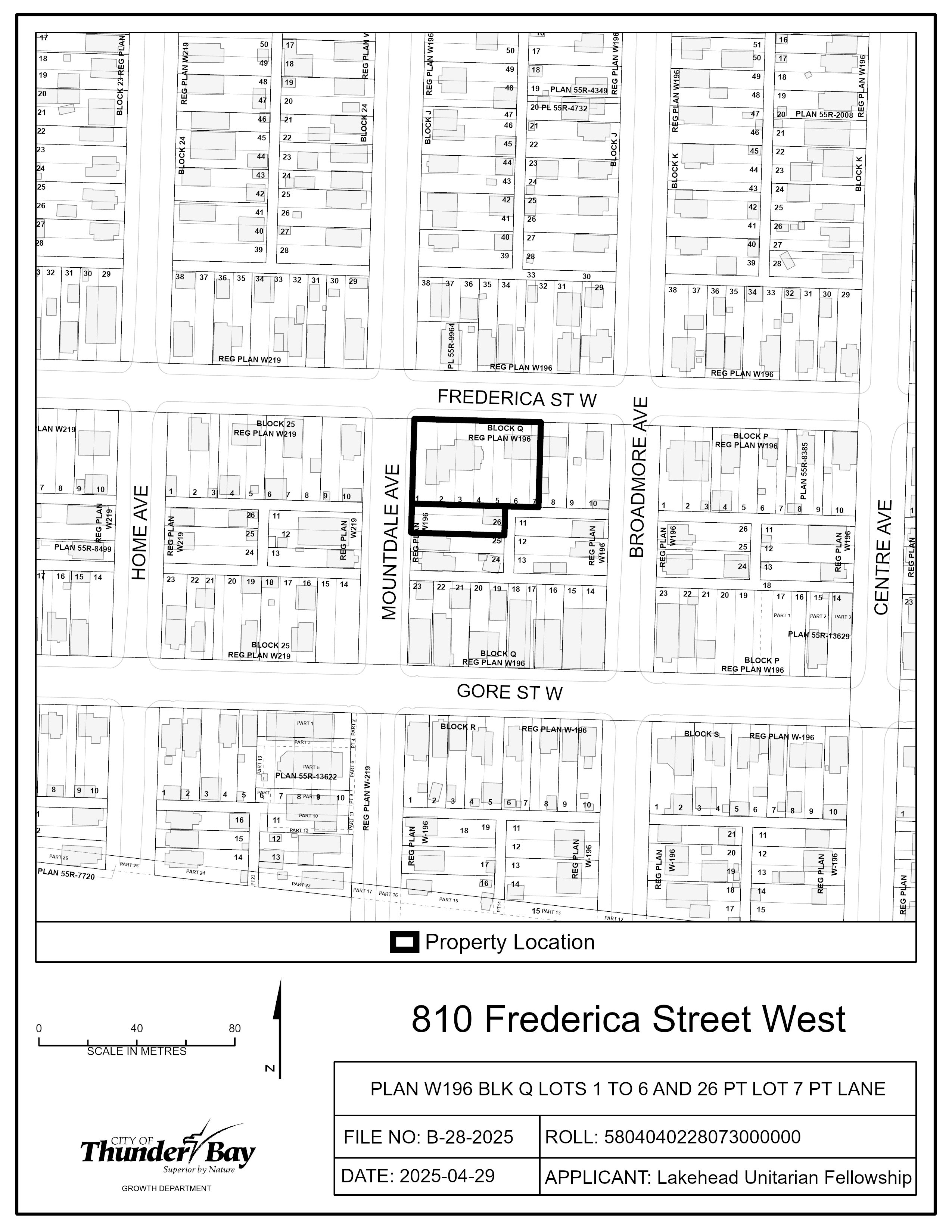
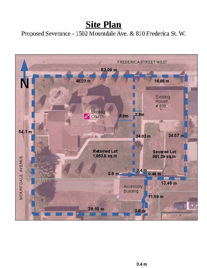
B-28-2025: 810 Frederica Street West
The purpose of this application is to create one new parcel of land.
The Severed Lot would have a Lot Frontage of 16.86 m, Lot Depth of 34.57 m and Lot Area of 581.39 m2. The Retained Lot would have a Lot Frontage of 46.23 m, Lot Depth of 54.1 m and Lot Area of 1 653.8 m2.
If approved, the effect of this application would be the severance and conveyance of one new parcel and to establish any easements as may be required for servicing, as set forth in the application.
The lands are zoned “UM” – Urban Mid-rise Zone and designated as “Residential” in the Official Plan. The applicant’s site sketch and a key map of the subject lands are shown below.
The subject lands are not subject to any other application under the Planning Act at this time.
Key Map of Subject Lands
Applicant's Site Sketch
Minor Variance Applications
A-17-2025: 554 Strand Avenue
The purpose of this application is to gain relief from Zoning By-law 1-2022, as set forth in the application and described below:
- Table 3.2.1, Reduce the minimum Rear Setback of the retained parcel from 6.0 m to 4.7 m
- Table 3.2.1, Reduce the minimum Front Setback of the severed parcel from 4.5 m to 3.0 m
- Table 3.2.1, Reduce the minimum Rear Setback of the severed parcel from 6.0 m to 3.0 m
If approved, the effect of this application would recognize the existing house on the retained parcel and permit the construction of a detached house on the severed parcel.
The subject lands are zoned “UL” – Urban Low-rise Zone and designated as “Residential” in the Official Plan. The applicant’s site sketch and a key map of the subject lands are shown below.
The subject lands are not subject to any other application under the Planning Act at this time.
Key Map of Subject Lands
Applicant's Site Sketch
A-18-2025: 3220 Wilroy Avenue
The purpose of the application is to gain relief from Zoning By-law 1-2022, as set forth in the application and described below:
- Table 3.2.2, Reduce the minimum Exterior Side Setback from 3.6 m to 0.76 m
- Table 3.2.2, Reduce the minimum Separation Distance between an eave and a Lot Line from 0.3 m to 0.15 m
- Table 3.2.2, Increase the maximum Wall Height from 3.2 m to 4.1 m
If approved, the effect of this application would recognize the location of the existing garage on the subject lands.
The subject lands are zoned “ULH14” – Urban Low-rise Zone with Development Holding Provision 14 and designated as “Residential” in the Official Plan. The applicant’s site sketch and a key map of the subject lands are shown below.
The subject lands are not subject to any other application under the Planning Act at this time.
Key Map of Subject Lands
Applicant's Site Sketch
A-21-2025: 1360 Gore Street West
The purpose of the application is to gain relief from Zoning By-law 1-2022, as set forth in the application and described below:
- Table 3.1.1a, Reduce the minimum Lot Area for 4 Homes from 540 m2 to 470.92 m2
- Table 3.2.1c, Reduce the minimum Rear Setback from 6 m to 4.2 m
If approved, the effect of this application would be the construction of a four-plex on the subject lands.
The subject lands are zoned “UL” – Urban Low-rise Zone and designated as “Residential” in the Official Plan. The applicant’s site sketch and a key map of the subject lands are shown below.
The subject lands are not subject to any other application under the Planning Act at this time.
Key Map of Subject Lands
Applicant's Site Sketch
A-22-2025: 401 Grenville Avenue
The purpose of the application is to gain relief from Zoning By-law 1-2022, as set forth in the application and described below:
- Table 3.2.1a, Reduce the minimum Front Setback from 4.5 m to 2.8 m
- Table 3.2.1a, Reduce the minimum Interior Side Setback from 1.5 m to 1 m
- Table 3.2.2, Increase the maximum GFA of all Accessory Buildings from 100 m2 to 217 m2
- Table 3.2.2, Increase the maximum GFA of a Backyard Home from 40% of the Main Building’s GFA to 42%
- Table 3.2.2, Increase the maximum Height from 4.6 m to 7 m
- Table 3.2.2, Increase the maximum Wall Height from 3.2 m to 5.4 m
- Table 3.3a, Reduce the minimum Landscaped Area from 50% of the minimum Front Setback to 23% of the minimum Front Setback
- Table 11.7.2a, Reduce the minimum Driveway width from 4.5 m for two-way traffic to 3.3 m
- Section 14, Change the definition of a Detached house from a residential Building containing up to 2 Homes to a residential Building containing up to 3 Homes
If approved, the effect of this application would recognize the existing conditions on the property to allow the construction of a Backyard Home on the Subject Lands.
The subject lands are zoned “UL” – Urban Low-rise Zone and designated as “Residential” in the Official Plan. The applicant’s site sketch and a key map of the subject lands are shown below.
The subject lands are not subject to any other application under the Planning Act at this time.
Key Map of Subject Lands
Applicant's Site Sketch
A-23-2025: 369 Dufferin Street
To gain relief from Zoning By-law 1-2022, as set forth in the application and described below:
- Table 3.1.1a, Increase the maximum Lot Coverage from 40% to 45.3%
- Table 3.2.1c, Reduce the minimum Front Setback from 4.5 m to 4.1 m
- Table 3.2.1c, Reduce the minimum Interior Side Setback from 1.5 m to 1.43 m
- Table 3.2.1c, Reduce the minimum Rear Setback from 6 m to 2.7 m
- Table 3.3b, Increase the maximum number of Driveways from 1 per additional 50 m of Street Line in excess of 31.0 m to 1 per additional 18.52 m in excess of 31.0 m
If approved, the effect of this application would be the construction of a four-plex on the subject lands.
The subject lands are zoned “UL” – Urban Low-rise Zone and designated as “Residential” in the Official Plan. The applicant’s site sketch and a key map of the subject lands are shown below.
The subject lands are not subject to any other application under the Planning Act at this time.
Key Map of Subject Lands
Applicant's Site Sketch
A-24-2025: Lot 331 High Street North
To gain relief from Zoning By-law 1-2022, as set forth in the application and described below:
- Table 3.2.1a, Reduce the minimum north Interior Side Setback from 3 m to 1.22 m
If approved, the effect of this application would be the construction of a single Detached House on the subject lands.
The subject lands are zoned “UL” – Urban Low-rise Zone and designated as “Residential” in the Official Plan. The applicant’s site sketch and a key map of the subject lands are shown below.
The subject lands are not subject to any other application under the Planning Act at this time.
Key Map of Subject Lands
Applicant's Site Sketch
A-25-2025: 81 Elizabeth Street
To gain relief from Zoning By-law 1-2022, as set forth in the application and described below:
- Table 3.2.1a, Reduce the minimum east Interior Side Setback from 1.5 m to 0.0 m
- Table 3.3a, Increase the maximum Driveway Width from 6.0 m to 9.8 m
- Table 11.2.4, Reduce the minimum distance of an architectural feature from a lot line (east) from 0.3 m to 0.0 m
If approved, the effect of this application would be the construction of a single Detached House with an Attached garage.
The subject lands are zoned “UL” – Urban Low-rise Zone and designated as “Residential” in the Official Plan. The applicant’s site sketch and a key map of the subject lands are shown below.
The subject lands are not subject to any other application under the Planning Act at this time.
Key Map of Subject Lands
Applicant's Site Sketch
A-26-2025: 243 Manitou Street
To gain relief from Zoning By-law 1-2022, as set forth in the application and described below:
- Table 4.2, Increase the maximum Exterior Side Setback from 3 m to 3.8 m
- Table 4.3, Vary the minimum number of Bicycle Spaces from 0 short term spaces and 2 long term spaces to 2 short term spaces and 0 long term spaces
If approved, the effect of this application would be the construction of a triplex on the subject lands.
The subject lands are zoned “DN” – Downtown Neighbourhood Zone and designated as “Strategic Core” in the Official Plan. The applicant’s site sketch and a key map of the subject lands are shown below.
The subject lands are not subject to any other application under the Planning Act at this time.
Key Map of Subject Lands
Applicant's Site Sketch
A-27-2025: 1620 John Street Road
To gain relief from Zoning By-law 1-2022, as set forth in the application and described below:
- Table 10.2.2, Increase the maximum GFA of Accessory Buildings from 100 m2 to 325 m2
- Table 10.2.2, Increase the maximum Wall Height from 3.2 m to 3.7 m
- Table 10.2.2, Increase the maximum Height from 4.6 m to 6.8 m
If approved, the effect of this application would be the construction of a detached garage on the subject lands.
The subject lands are zoned “UG” – Urban Growth Zone and designated as “Growth Area” in the Official Plan. The applicant’s site sketch and a key map of the subject lands are shown below.
The subject lands are not subject to any other application under the Planning Act at this time.
Key Map of Subject Lands
Applicant's Site Sketch
Contact Us