


Notice of Committee Hearing
The Public is invited to participate in a Committee of Adjustment Hearing on Thursday, October 30, 2025 at 2:00 p.m.
How to Participate
Submit written comments, by emailing Arden.Irish@thunderbay.ca no later than Monday, October 27, 2025. Please quote the file number in your submission.
Participate online using Microsoft Teams. Online participants must register by the end of the day on Monday, October 27, 2025. Please email Arden.Irish@thunderbay.ca to register.
Attend in person, by visiting Council Chambers on the 3rd Floor of City Hall (500 Donald Street East)
Watch live from home by visiting www.thunderbay.ca/watchcouncil
Additional Information
If you wish to be notified of the decision of the Committee of Adjustment in respect of the proposed consent, you must submit a written request to Arden.Irish@thunderbay.ca.
Copies of all comments will be forwarded to the Committee and to the Applicant. The collection of personal information including names and contact information provided in written submissions is made under the authority of the Planning Act for the purpose of creating a Public Record. Personal information is collected in compliance with the Municipal Freedom of Information and Protection of Privacy Act.
Right to Appeal
Only the applicant, the Minister or a specified person or public body that has an interest in the matter may, within 20 days of the making of the decision, appeal to the Ontario Land Tribunal against the decision of the Committee of Adjustment.
Questions?
If you have any questions about this notice or you require accessible accommodations or materials, please contact:
Arden Irish
Acting Committee of Adjustment Secretary Treasurer
(807) 625-2704
Consent to Sever Applications
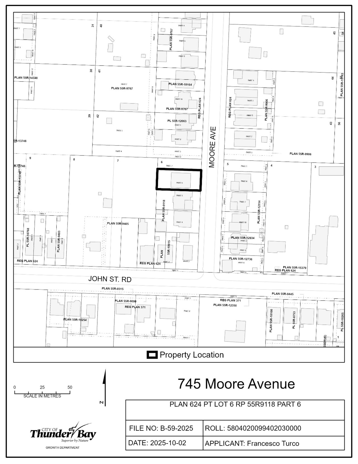
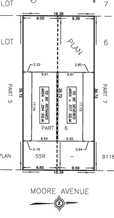
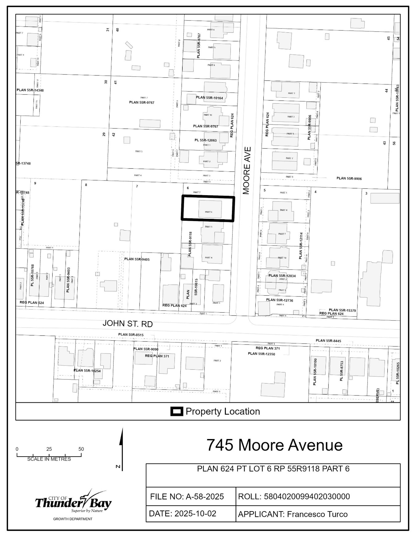
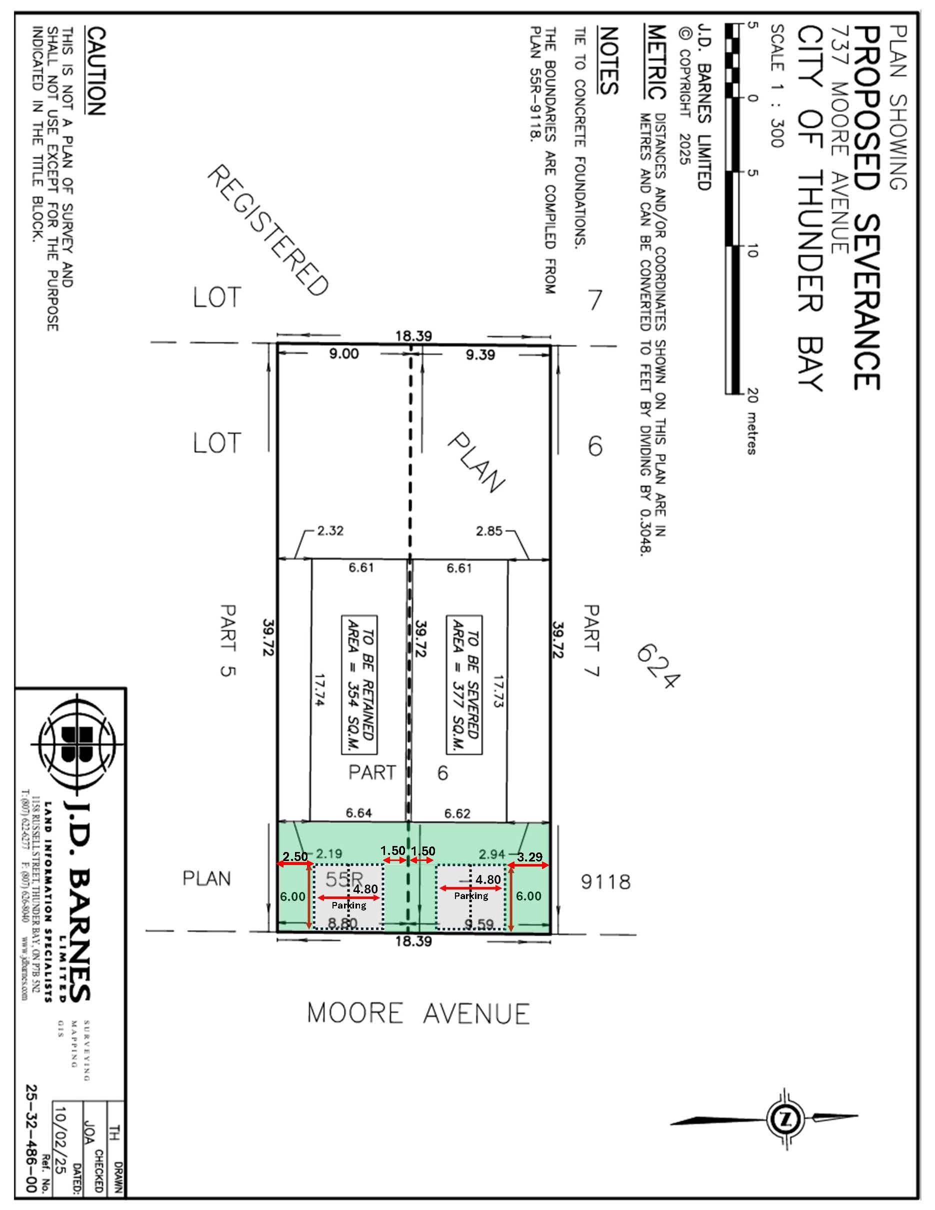
B-59-2025: 745 Moore Avenue
The purpose of this application is to create one new parcel of land.
The severed lot would have an approximate Lot Frontage of 9.59 m, Lot Depth of 39.72 m and Lot Area of 377 m2. The retained lot would have an approximate Lot Frontage of 8.80 m, Lot Depth of 39.72 m and Lot Area of 354 m2.
If approved, the effect of this application would be the severance and conveyance of one new parcel of land and to establish any easements as may be required for servicing, as set forth in the application.
The lands are zoned “UL” – Urban Low-rise Zone and is designated “Residential” in the Official Plan. A key map of the subject lands and the applicant’s site-sketch are shown below.
The subject lands are also subject to an application for the minor variance A-58-2025, being considered concurrently on Thursday, October 30th.
Key Map of Subject Lands
Applicant's Site Sketch
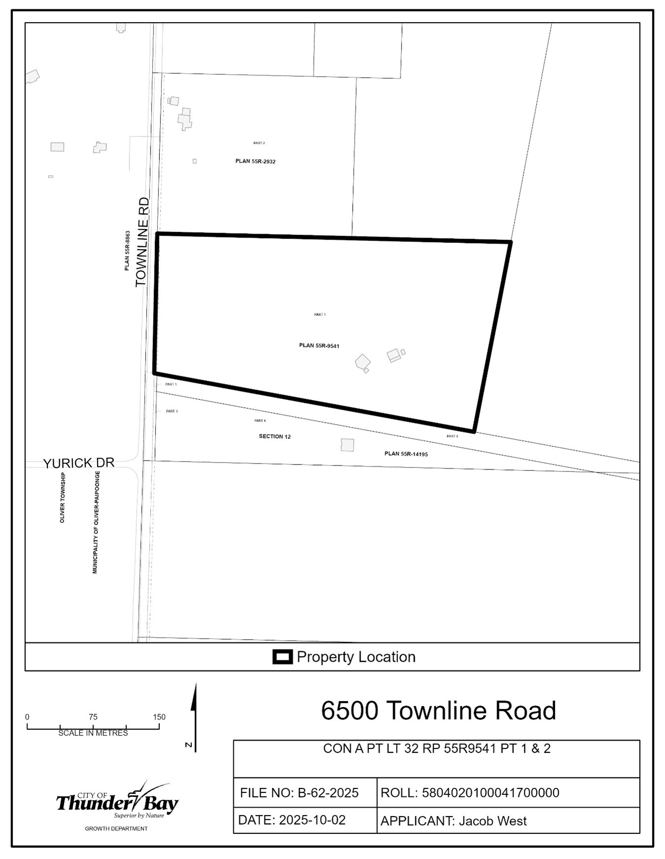
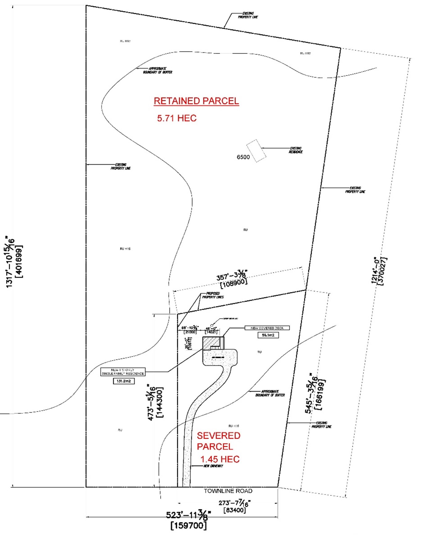
B-62-2025: 6500 Townline Road
The purpose of this application is to create one new parcel of land.
The severed lot would have an approximate Lot Frontage of 83.4 m, an irregular Lot Depth of 166 m and Lot Area of 1.45 Hectares. The retained lot would have an approximate Lot Frontage of 76.3 m, an irregular Lot Depth of 401 m and Lot Area of 5.71 Hectares.
If approved, the effect of this application would be the severance and conveyance of one new parcel of land and to establish any easements as may be required for servicing, as set forth in the application.
The lands are zoned “RU” – Rural Zone and “RUH15” – Rural Zone with Development Holding Provision 15, and is designated “Rural 1”, “Natural Corridor” and “Evaluated Wetland” in the Official Plan. A key map of the subject lands and the applicant’s site-sketch are shown below.
The subject lands are not subject to any other application under the Planning Act at this time.
Key Map of Subject Lands
Applicant's Site-sketch
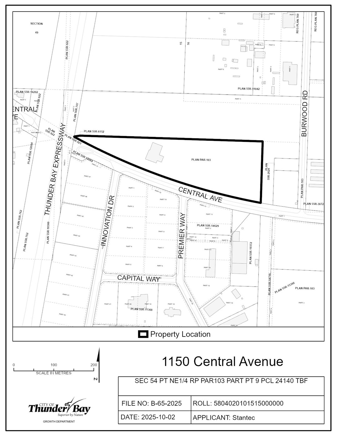
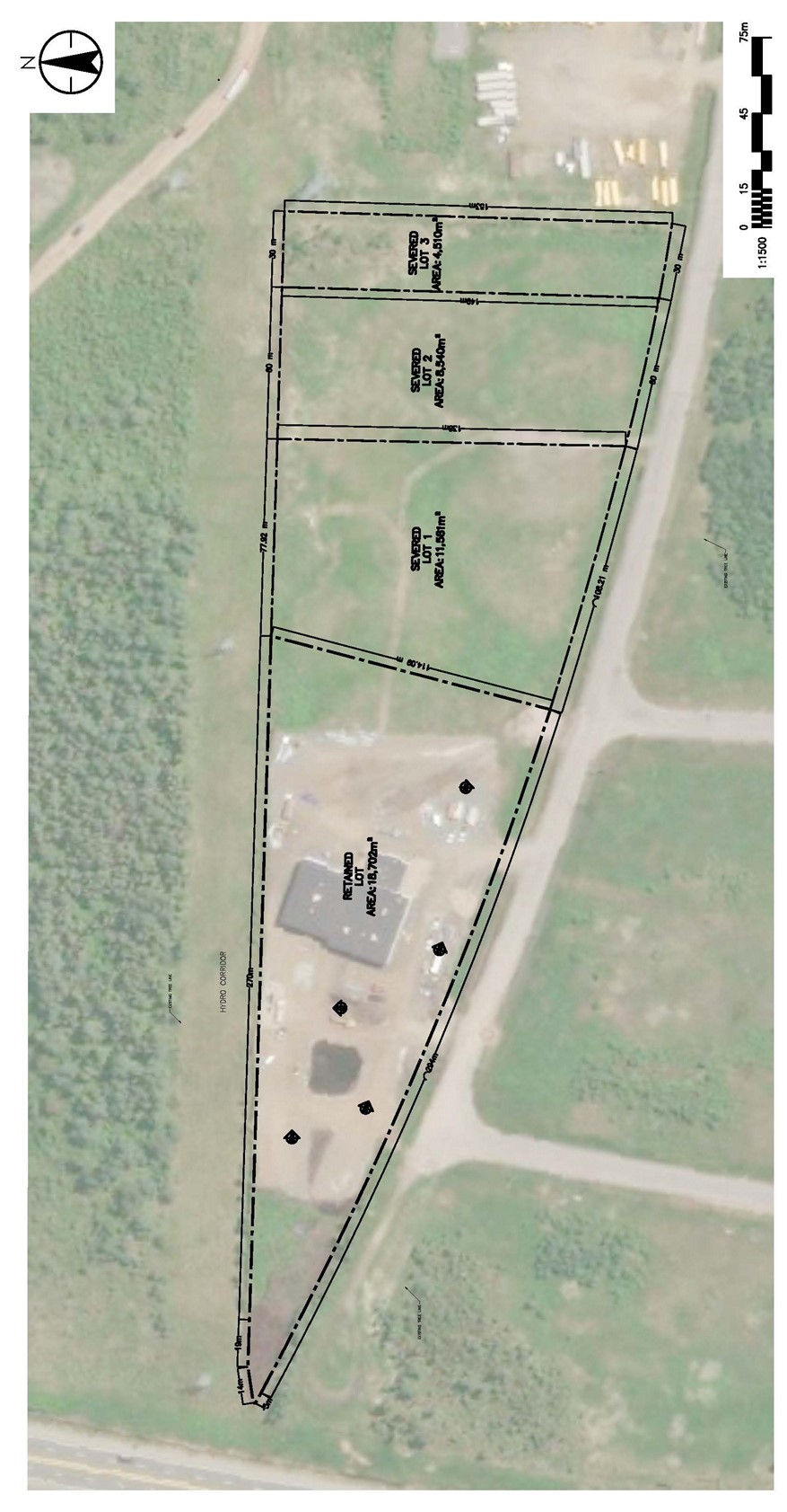
B-65-2025: 1150 Central Avenue
The purpose of this application is to create three new parcels of land.
Severed Lot One (1) would have an approximate Lot Frontage of 108.21 m, an irregular Lot Depth of 138 m and Lot Area of 11 581 m2. Severed Lot Two (2) would have an approximate Lot Frontage of 60 m, an irregular Lot Depth of 149 m and Lot Area of 8 540 m2. Severed Lot Three (3) would have an approximate Lot Frontage of 30 m, an irregular Lot Depth of 153 m and Lot Area of 4 510 m2.
The retained lot would have an approximate Lot Frontage of 294 m, an irregular Lot Depth of 114 m and Lot Area of 18 702 m2.
If approved, the effect of this application would be the severance and conveyance of three new parcels of land and to establish any easements as may be required for servicing, as set forth in the application.
The lands are zoned “LI” – Light Industrial Zone and “BUSP81” – Business Zone with Site Specific Provision 81 and designated “Light Industrial” and “Business Area” in the Official Plan. A key map of the subject lands and the applicant’s site-sketch are shown below.
The subject lands are not subject to any other application under the Planning Act at this time.
Key Map of Subject Lands
Applicant's Site-sketch
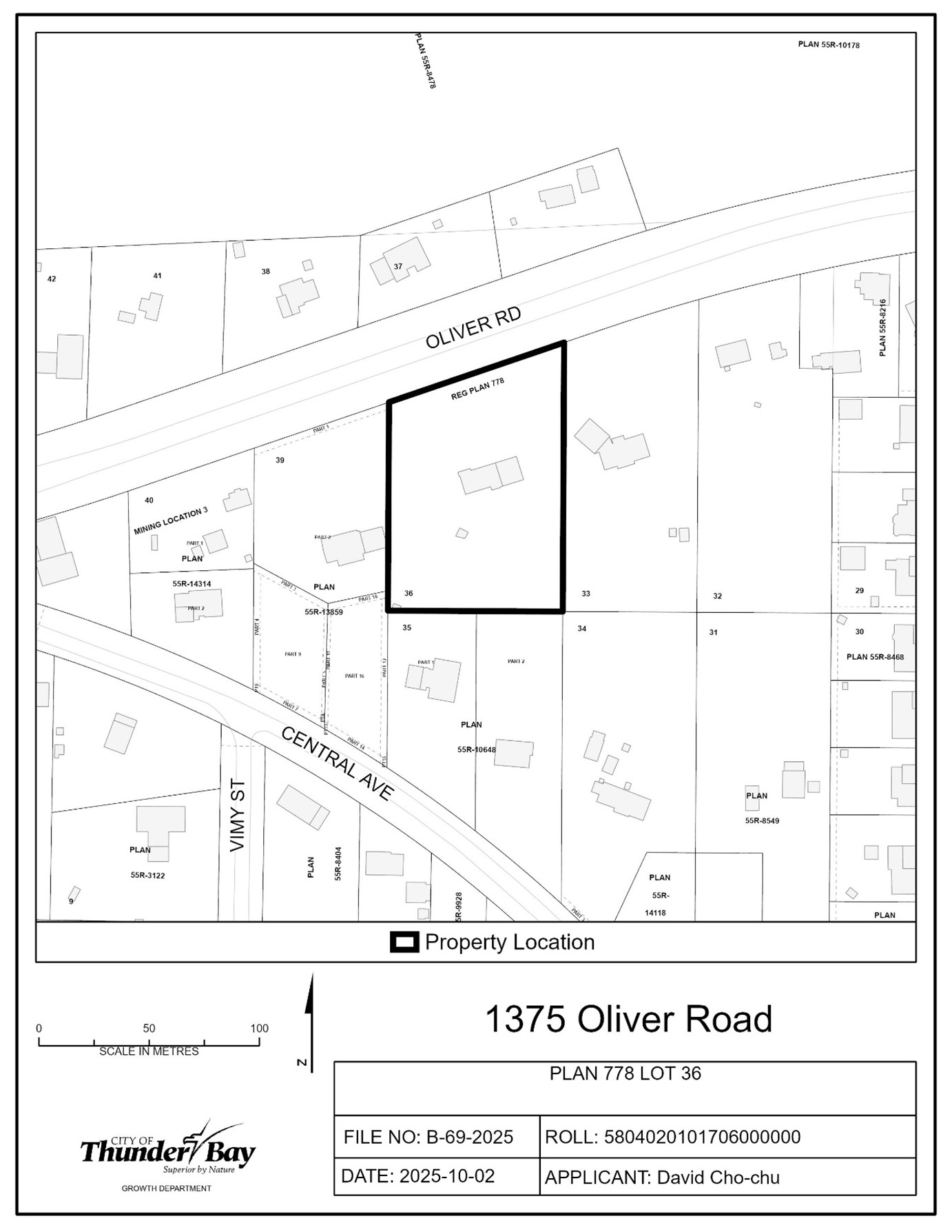
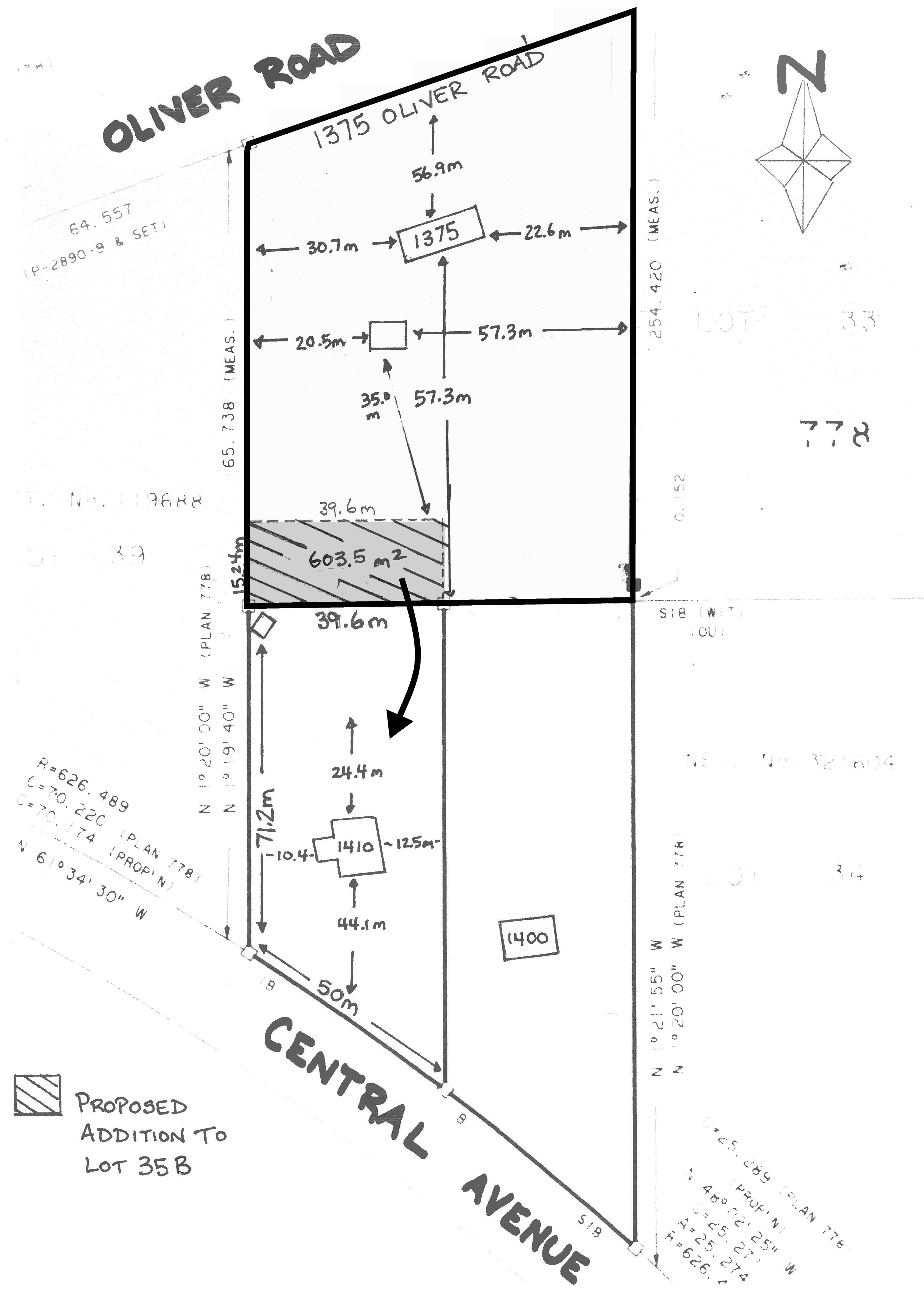
B-69-2025: 1375 Oliver Road
The purpose of this application is to permit a severance to facilitate a lot addition of approximately 603 m2 from 1375 Oliver Road to 1410 Central Avenue.
If approved, the effect of this application would increase the lot depth and area of 1410 Central Avenue.
The lands are zoned “UG” – Urban Growth Zone and designated “Growth Area” in the Official Plan. A key map of the subject lands and the applicant’s site-sketch are shown below.
The subject lands are not subject to any other application under the Planning Act at this time.
Key Map of Subject Lands
Applicant's Site-sketch
Minor Variance Applications
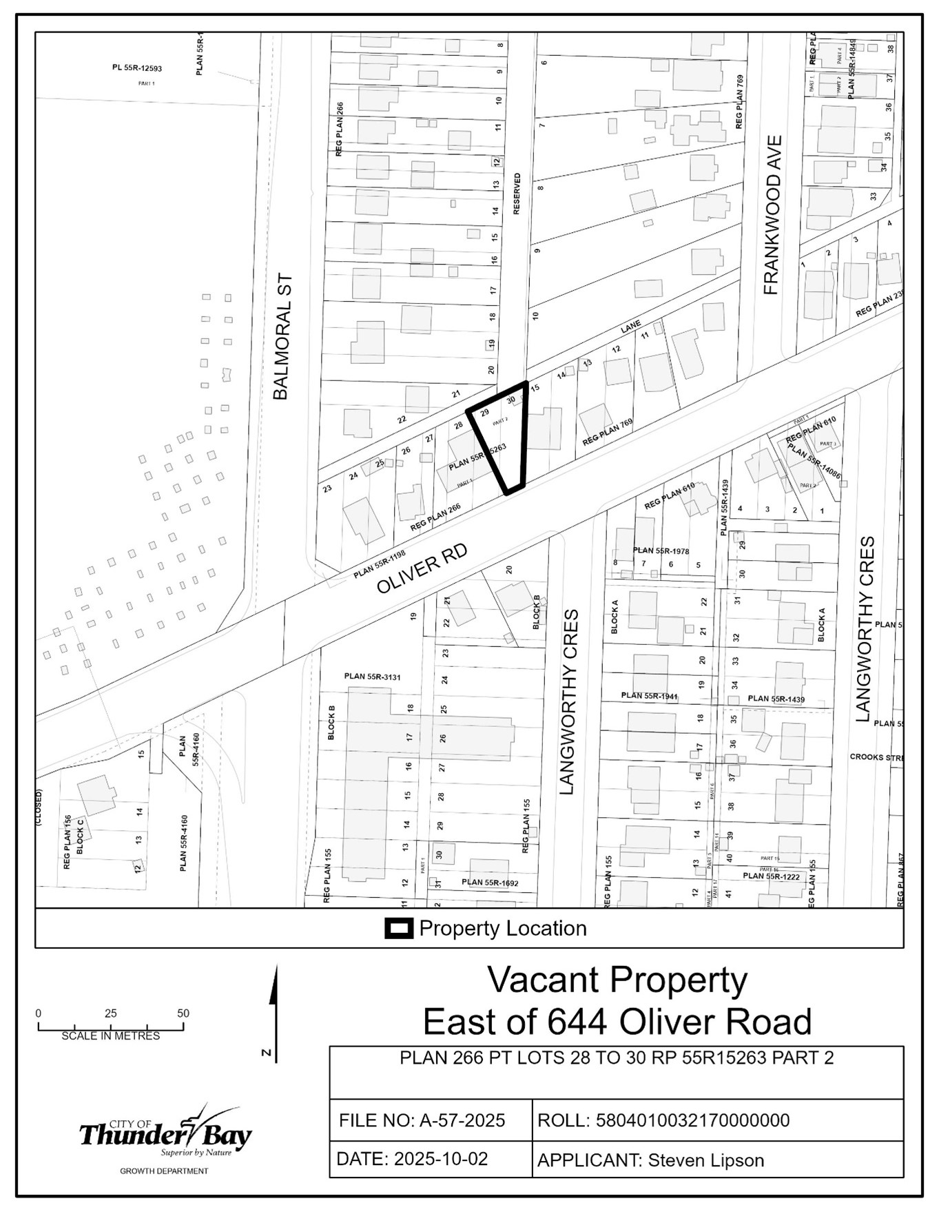
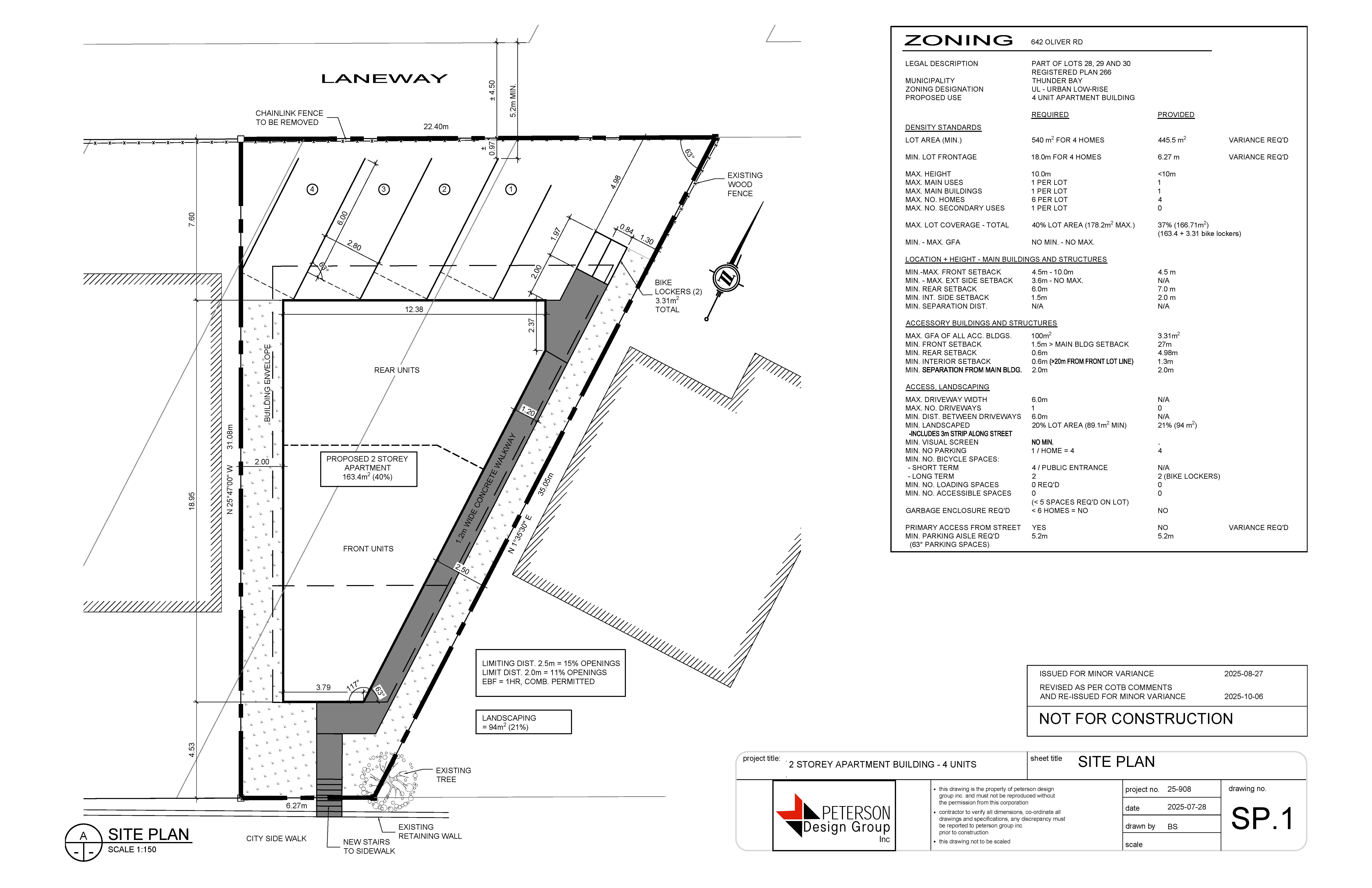
A-57-2025: 644 Oliver Road
The purpose of the application is to gain relief from Zoning By-law 1-2022, as set forth in the application and described in the table below:
|
Table 3.1.1a |
Reduce minimum lot area for 4 units from 540 m2 to 445.5 m2 |
| Table 3.1.1a | Reduce minimum lot frontage for 4 units from 18 m to 10.9 m |
| Section 11.1.2d | Permit primary access from a lane |
If approved, the effect of the application would be the construction of a four-unit apartment on the subject lands.
The subject lands are zoned “UL” – Urban Low-rise Zone, and “Residential” in the Official Plan. A key map of the subject lands and the applicant’s site-sketch are shown below.
The subject lands are not subject to any other application under the Planning Act at this time.
Key Map of Subject Lands
Applicant's Site-sketch
A-58-2025: 745 Moore Avenue
The purpose of the application is to gain relief from Zoning By-law 1-2022, as set forth in the application and described in the table below:
|
Table 3.1.1b |
Reduce the minimum lot frontage on the proposed retained lot from 9 m to 8.8 m |
| Table 3.2.1b | Reduce the minimum interior side setback from 3 m to 2.19 m on the proposed retained lot |
| Table 3.2.1b | Reduce the minimum exterior side setback from 3.6 m to 2.85 m on the proposed severed lot |
| Table 3.3a | Increase the maximum driveway width from 50% of lot frontage to 55% on the proposed retained lot |
| Table 3.3a | Reduce the minimum landscaped area from 50% of the minimum front setback to 45% on the proposed retained lot |
If approved, the effect of the application would be to facilitate a severance of the existing semi-detached house.
The subject lands are zoned “UL” – Urban Low-rise Zone, and “Residential” in the Official Plan. A key map of the subject lands and the applicant’s site-sketch are shown below.
The subject lands are also subject to an application for the minor variance B-59-2025, being considered concurrently on Thursday, October 30th.
Key Map of Subject Lands
Applicant's Site-sketch
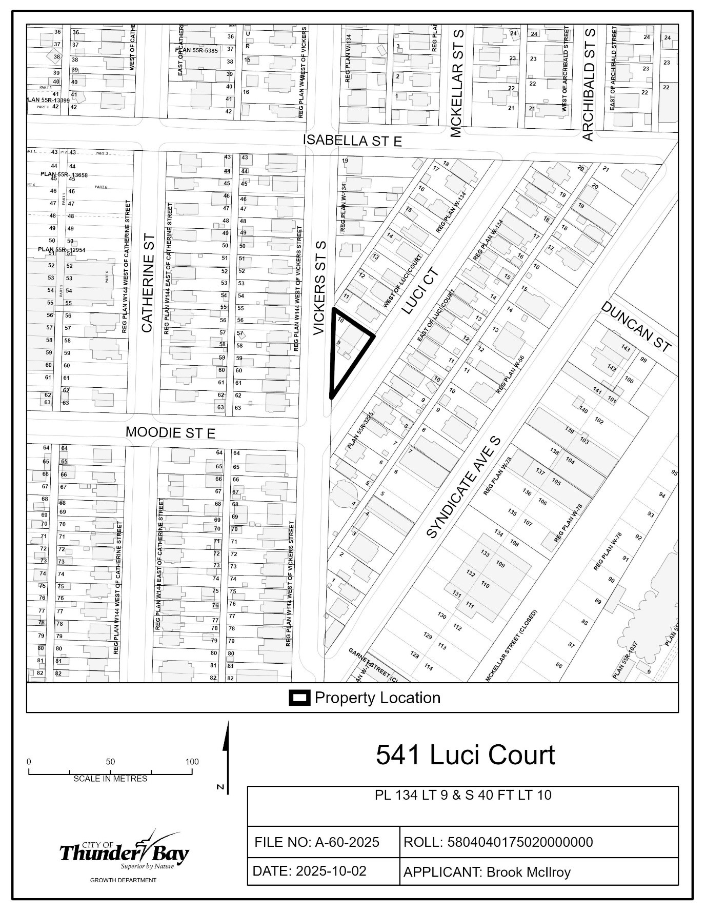
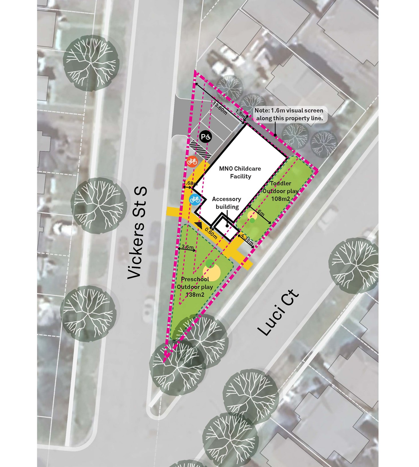
A-60-2025: 541 Luci Court
The purpose of the application is to seek permission under Section 45(2)a)i) of the Planning Act to establish a change of use in the building containing a legal non-conforming use on the subject lands. The Permission application includes a change of use from an Educational Institution to a Day Care Centre.
The lands are zoned “UL” – Urban Low-rise and designated “Residential” in the Official Plan. The applicant’s site sketch and a key map of the subject lands are shown below.
The subject lands are not subject to any other application under the Planning Act at this time.
Key Map of Subject Lands
Applicant's Site-sketch
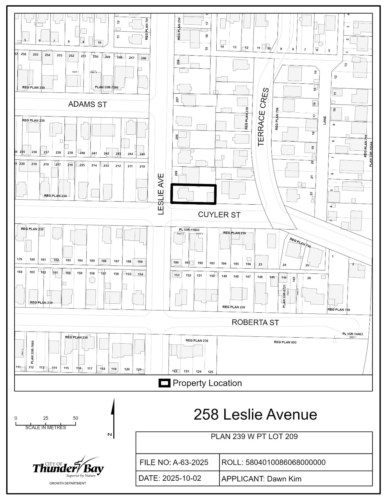
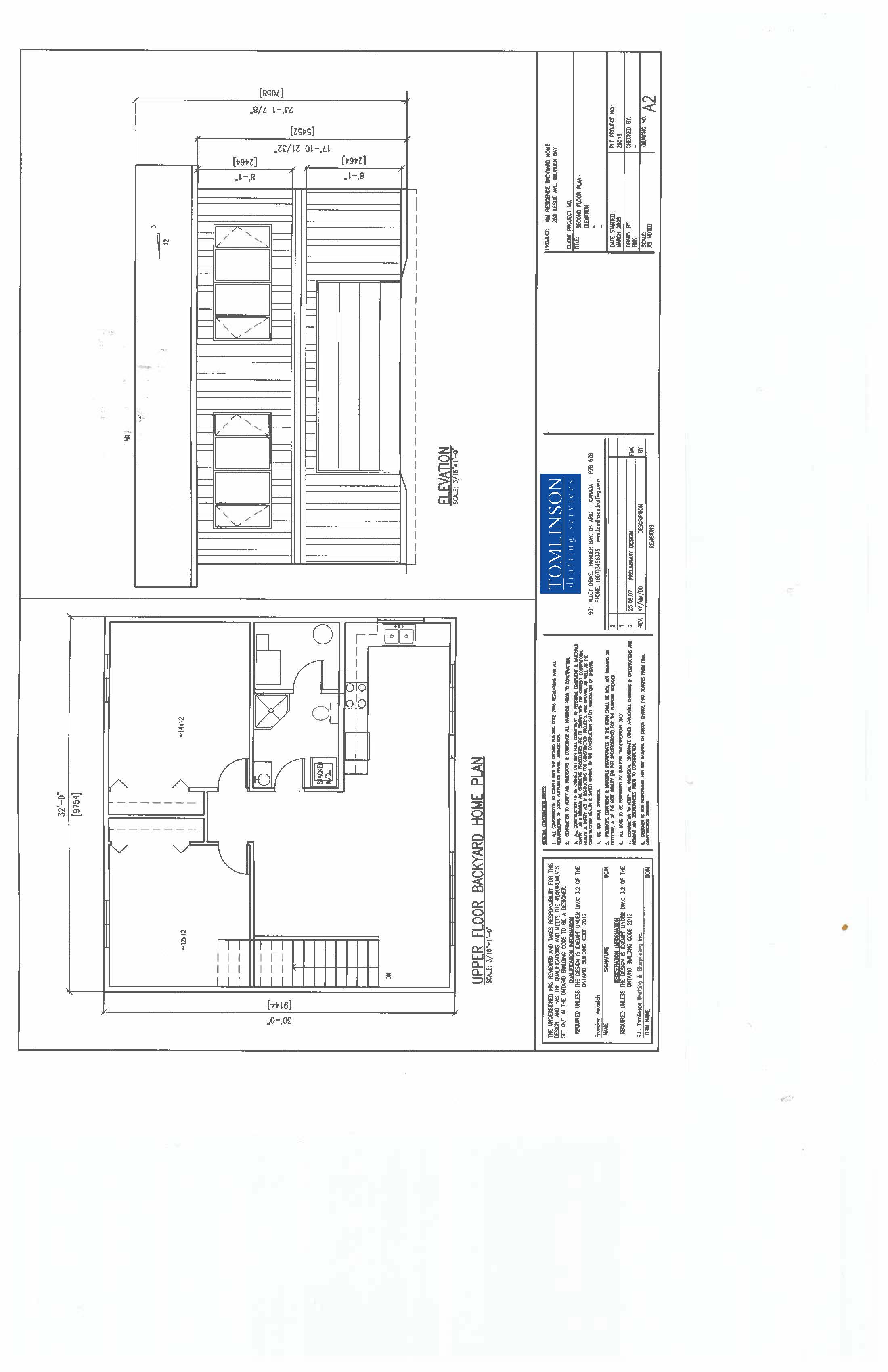
A-63-2025: 258 Leslie Avenue
The purpose of the application is to gain relief from Zoning By-law 1-2022, as set forth in the application and described in the table below:
|
Table 3.2.2 |
Increase the maximum GFA of a backyard home from 40% of main building GFA (73.25 m2) to 48.7% (89.2 m2) |
|
Table 3.2.2 |
Increase the maximum height of an accessory structure from 4.6 m to 7.06 m |
| Table 3.2.2 | Increase the maximum wall height of an accessory structure from 3.2 m to 5.452 m |
| Table 3.2.2 | Increase the max GFA for an accessory building from 100 m2 to 178.5 m2 |
If approved, the effect of the application would be the construction of a detached garage with a backyard home on the second storey.
The subject lands are zoned “UL” – Urban Low-rise Zone, and “Residential” in the Official Plan. A key map of the subject lands and the applicant’s site-sketch are shown below.
The subject lands are not subject to any other application under the Planning Act at this time.
Key Map of Subject Lands
Applicant's Site-sketch
Applicant's Elevation
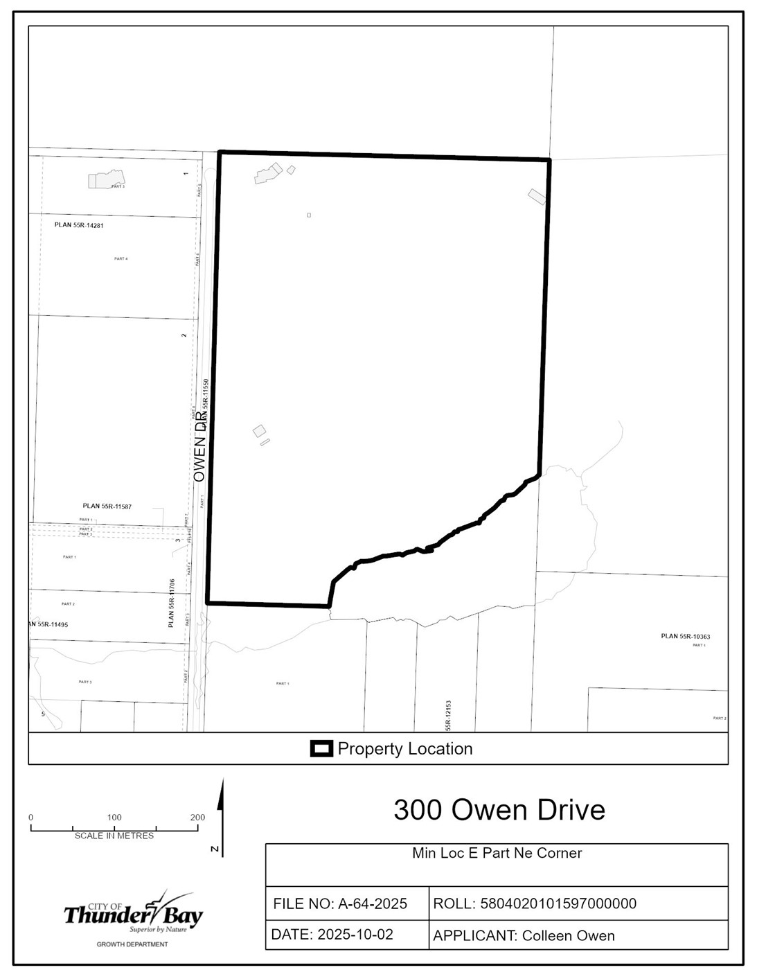
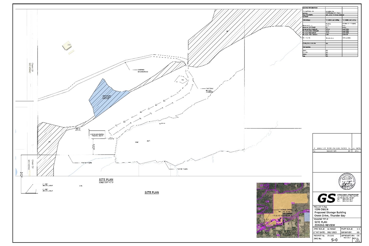
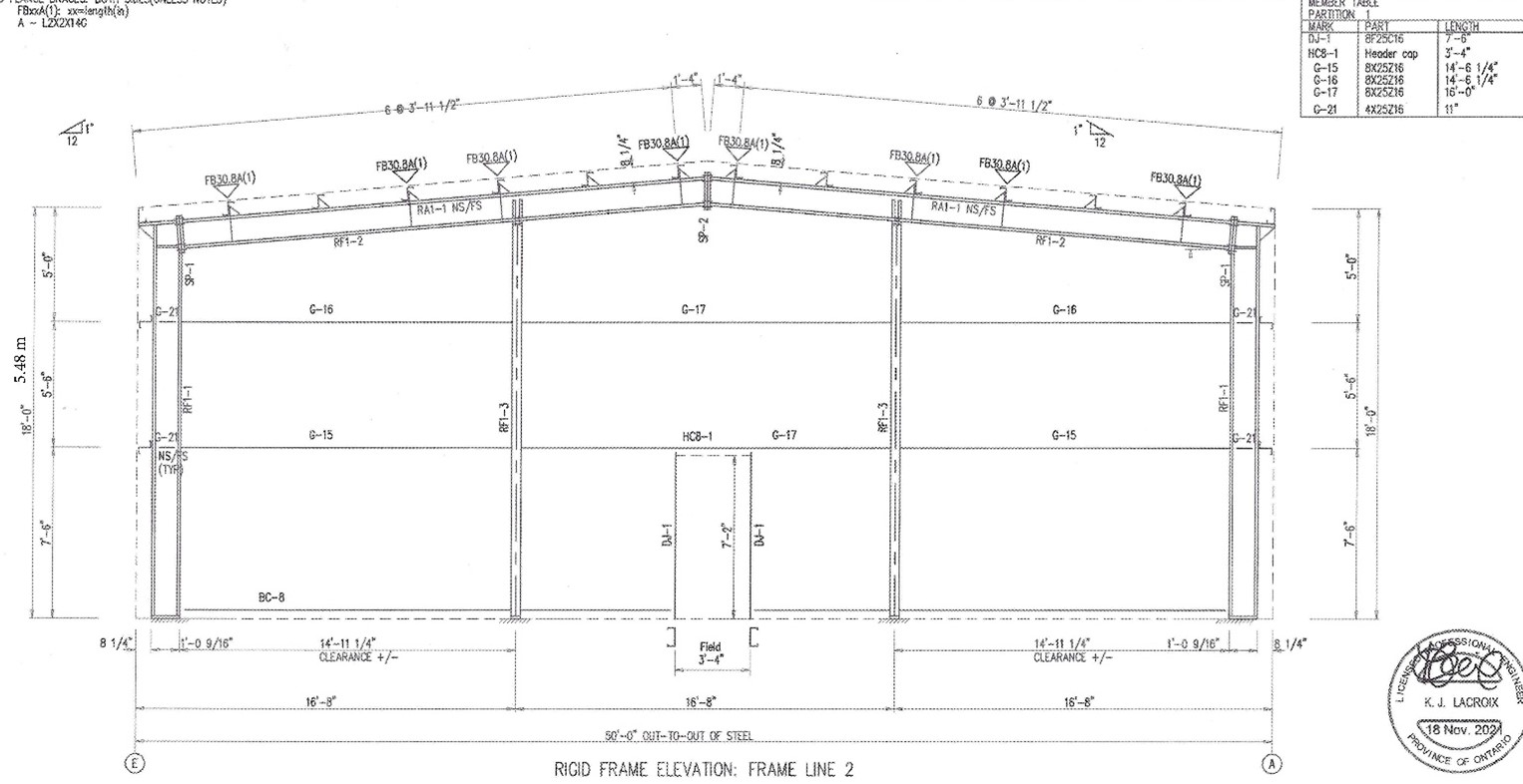
A-64-2025: 300 Owen Drive
The purpose of the application is to gain relief from Zoning By-law 1-2022, as set forth in the application and described in the table below:
|
Table 1.2.2b |
Increase the maximum Ground Floor Area of all accessory structures from 300 m2 to 499 m2 |
|
Table 1.2.2b |
Increase the maximum wall height of an accessory structure from 4.5 m to 5.48 m |
If approved, the effect of the application would be the construction of an accessory building on the subject lands with 464 m2 of Ground Floor Area.
The subject lands are zoned “RUSP34” – Rural Zone with Site Specific Provision 34, “EP” – Environmental Protection Zone and designated “Rural 1”, “Evaluated Wetland” and “Natural Corridor” in the Official Plan. A key map of the subject lands and the applicant’s site-sketch are shown below.
The subject lands are not subject to any other application under the Planning Act at this time.
Key Map of Subject Lands
Applicant's Site-sketch
Applicant's Elevations
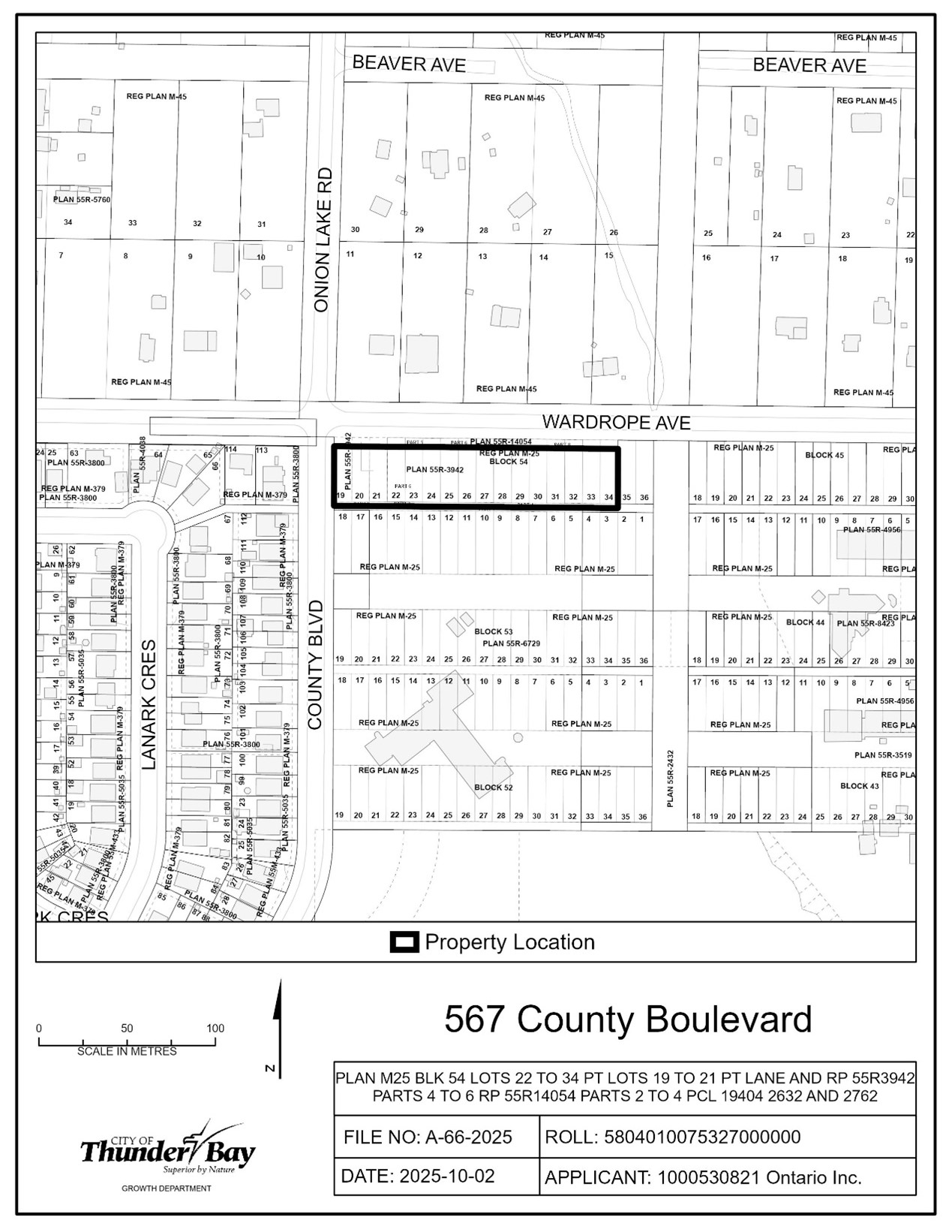
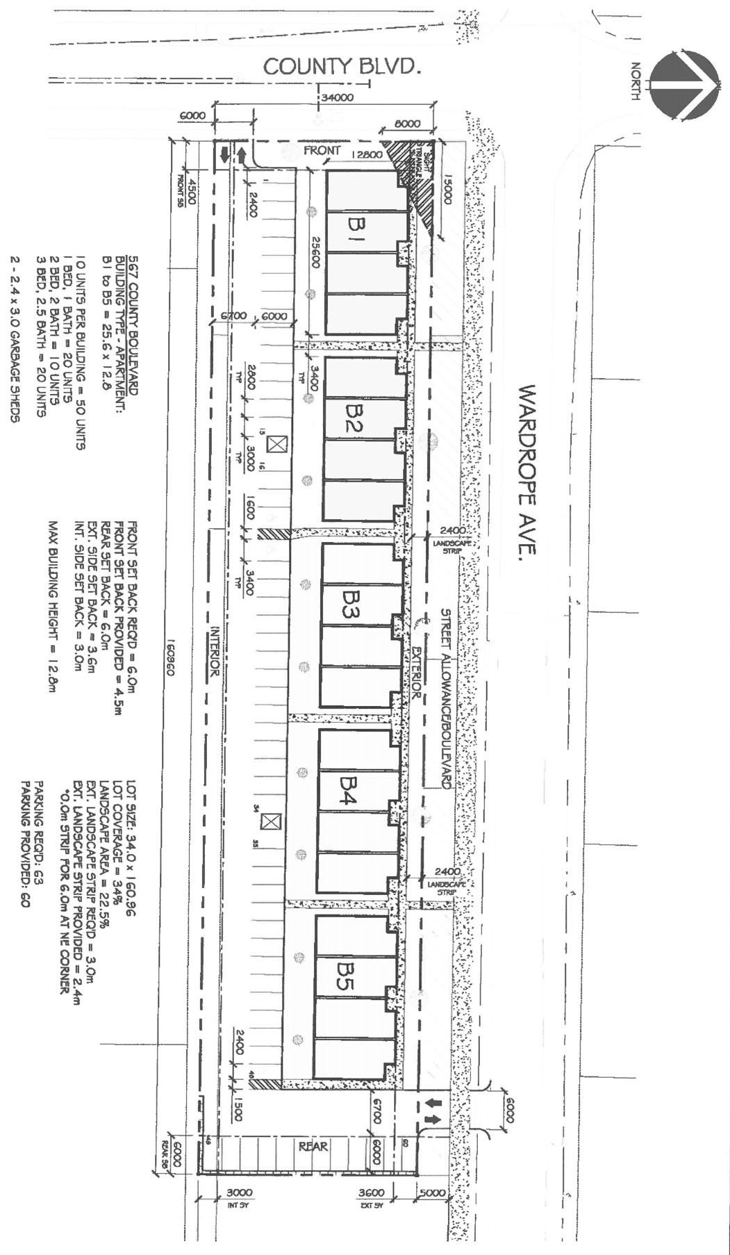
A-66-2025: 567 County Boulevard
The purpose of the application is to gain relief from Zoning By-law 1-2022, as set forth in the application and described in the table below:
|
Table 3.2.1d |
Reduce the minimum front setback from 6 m to 4.5 m |
|
Table 3.3b |
Reduce the minimum parking spaces from 63 spaces to 60 |
| Table 3.3b | Reduce the minimum landscaped strip from 3 m abutting a street allowance to 2.4 m along Wardrope Avenue and 0 m on the northeast corner for a parking space |
| Table 11.8 | Reduce the sight triangle from 15 by 8 m to 15 by 6 m |
If approved, the effect of the application would be the construction of five ten-unit apartments on the subject lands.
The subject lands are zoned “UMSP53” – Urban Mid-rise Zone and designated “Residential” and “Natural Corridor” in the Official Plan. A key map of the subject lands and the applicant’s site-sketch are shown below.
The subject lands are not subject to any other application under the Planning Act at this time.
Key Map of Subject Lands
Applicant's Site-sketch
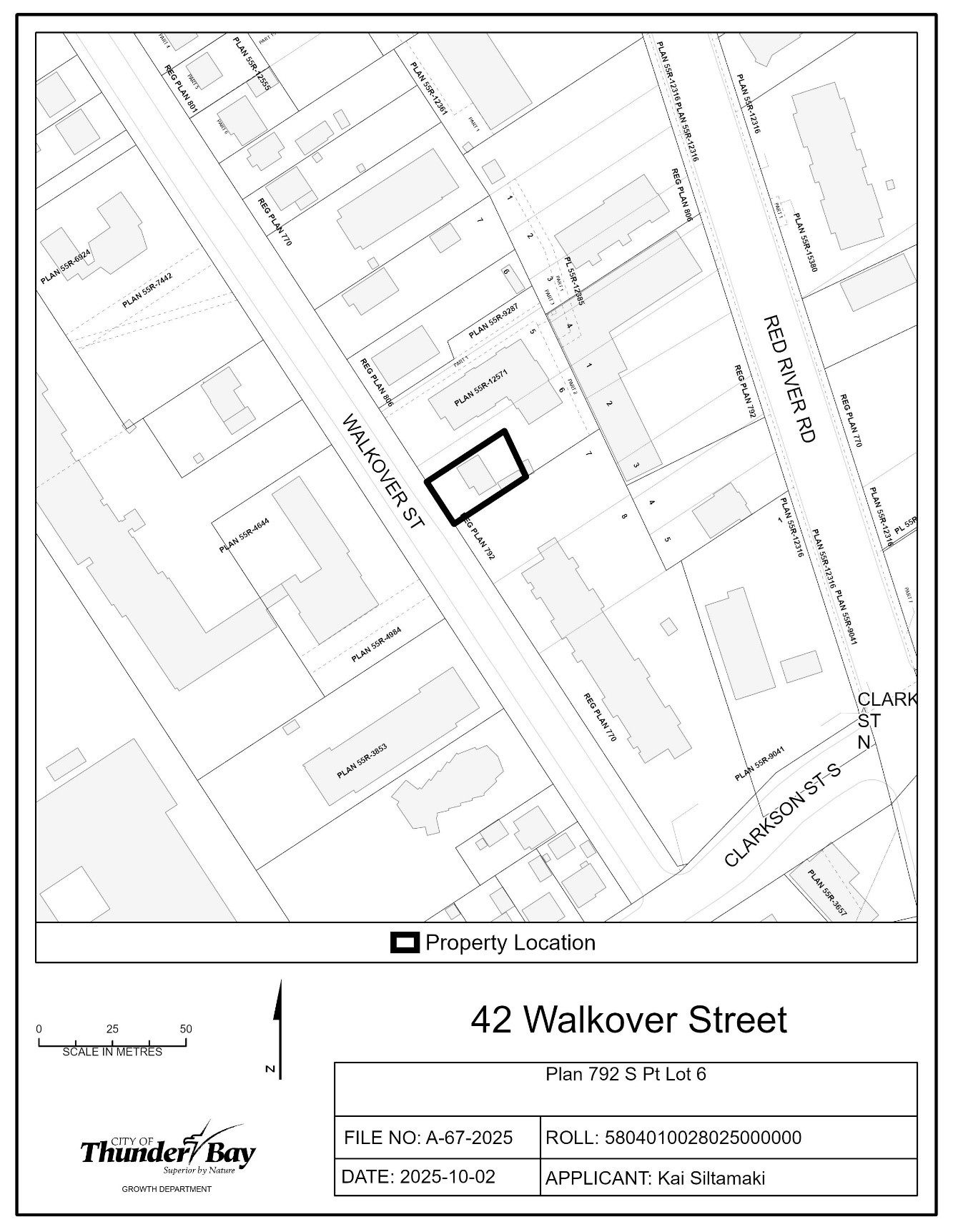
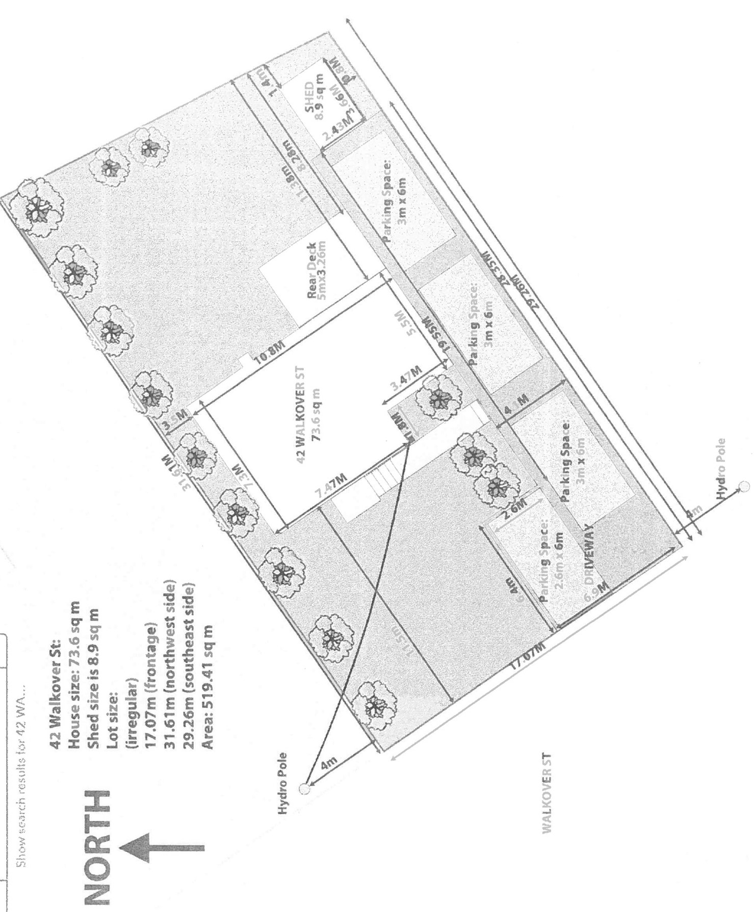
A-67-2025: 42 Walkover Street
The purpose of the application is to seek permission under Section 45(2)a)i) of the Planning Act to expand the legal non-conforming Detached House on the subject lands to include a second unit.
If approved, the effect of this application would permit the conversion of the basement into an Additional Dwelling Unit on the subject lands.
The lands are zoned “UM” – Urban Mid-rise and designated “Residential” in the Official Plan. The applicant’s site sketch and a key map of the subject lands are shown below.
The subject lands are not subject to any other application under the Planning Act at this time.
Key Map of Subject Lands
Applicant's Site-sketch
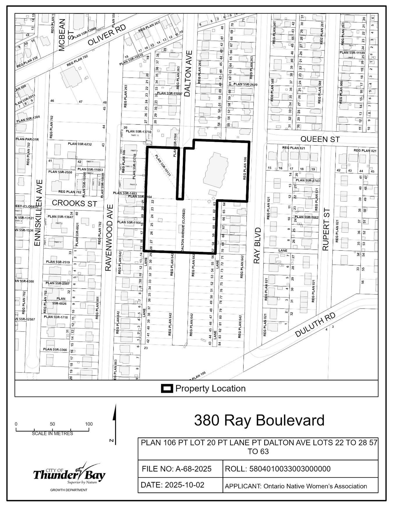
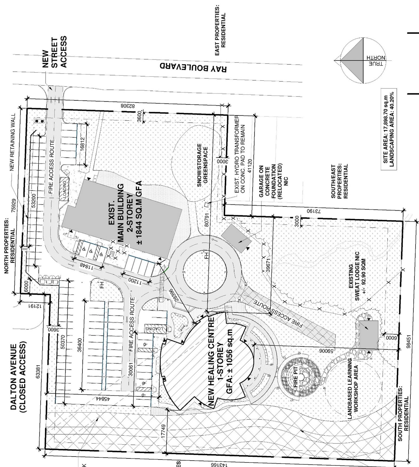
A-68-2025: 380 Ray Boulevard
The purpose of the application is to gain relief from Zoning By-law 1-2022, as set forth in the application and described in the table below:
|
Table 3.1.2a |
Reduce the minimum height from 2 storeys to 1 storey |
|
Table 3.3c |
Reduce the minimum landscaped strip along a street allowance from 3 m to 2 m along the north interior lot line |
| Section 11.11 | Permit a Waste Storage Enclosure in the front setback |
If approved, the effect of the application would be the construction of a single storey well-being centre.
The subject lands are zoned “UMSP22” – Urban Mid-rise Zone with the Site-Specific Provision 22, and designated “Residential” in the Official Plan. A key map of the subject lands and the applicant’s site-sketch are shown below.
The subject lands are not subject to any other application under the Planning Act at this time.
Key Map of Subject Lands
Applicant's Site-sketch
Contact Us